A New Boulevard for Social Justice, Connectivity, and Economic Impact

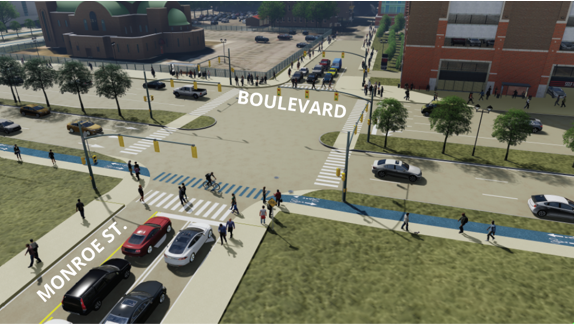
The development of I-375, the extension of I-75 that runs into downtown Detroit, leveled the Black Bottom residential neighborhood and the Paradise Valley entertainment district when it was constructed in the late 1950s and early 1960s with economic impact displacing 130,000 people, hundreds of small businesses, churches, and more. The city has been divided by the highway for over 70 years. Now, the Michigan Department of Transportation (MDOT) is funneling $104,657,051 from the President’s Bipartisan Infrastructure Law that passed last year to replace the one-mile-long freeway and develop a lower-speed urban boulevard with the impetus to recognize the wrongdoing of the past and get it right for the future. The project proposes three elements of study, design, and research. The first is understanding the urban design profile … how this area is developed to reconnect Downtown Detroit and the riverfront to the surrounding neighborhoods. Second is the final boulevard design, which is intended to enhance the urban experience based on City of Detroit design standards and offer new economic opportunities via business development. Finally, the framework will determine how diversity, equity, and inclusion can be used to create opportunities for Detroiters, taking the history of the land into consideration. This is the first of a two-part article that will cover the project’s social justice, connectivity, and economic impacts. In this article, MDOT Director Paul C. Ajegba talked to SBN Detroit about this ‘very unique and challenging project.’ With more than 31 years of experience at MDOT, Ajegba established the position of chief culture, equity, and inclusion officer at the deputy director level within his leadership team. This followed his work to establish MDOT’s Historically Black Colleges and Universities (HBCU) Transportation Diversity Recruitment Program (TDRP). The program is a partnership between MDOT, the Federal Highway Administration (FHWA), the American Council of Engineering Companies of Michigan (ACEC), and Michigan colleges and universities, offering on-the-job training to minority undergraduate students pursuing degrees in engineering. Ajegba is a member of the Conference of Minority Transportation Officials (COMTO) and serves on the following boards: the American Association of State Highway and Transportation Officials (AASHTO) (vice president), chair of the AASHTO Council on Public Transportation, ITS America, Mcity, the University of Michigan Civil and Environmental Engineering Friends Association (board president), the Engineering Society of Detroit, and the . Q: What is the impetus behind the I-375 project? A: It is a way for us to recognize that things were not done right in the past, and it is our opportunity to get them right. In the early ‘50s, Black Bottom was a large community with many thriving African American residents and businesses. In those days we did not have the community engagement that we do now. City planners decided that the best use of the area was to build a freeway and they did it, causing the displacement of thousands of residents and many successful businesses. So, the impetus behind this project is to take a step back and rethink the way we plan and design, build our infrastructure and then build it with the users, stakeholders, businesses, and residents in mind. It is the opportunity to conduct a 360-degree review of all areas of impact and make decisions that are right for everyone. The equity and inclusion piece of this is huge. We are being meticulous and methodical in how we plan to make sure the community is engaged every step of the way. Q: What is the narrative around the topic of equity? A: We need to bring equity into our transportation infrastructure. We cannot erase the mistakes of the past, but what we can do is make sure we look through and operate through a lens of equity going forward. Several different uses of this area have been on the table. We engaged with the community and together decided that creating a boulevard that will attract new development and connect neighborhoods is the best use of the corridor. Q: How will this project honor the history of Black Bottom and Paradise Valley? A: We are currently in the design process and considering all different ways to do this and we are hiring a historian to help with this aspect. Recognizing and honoring what took place here will be built into the aesthetics of the whole corridor. You will see this reflected in the project overall. Q: Is this project part of a larger shift toward building state infrastructure with equity in mind? A: I think there is a big shift taking place not only in Michigan but across the country to rethink inclusivity when it comes to building infrastructure. There is a substantial focus on developing walkable communities, making sidewalks wider, incorporating bike lanes, and connecting neighborhoods with greenways. The walkable aspect gives local businesses in the area more foot traffic and access opportunity. I believe this is an equity issue, an economic issue and also a health issue. Making areas accessible for walks and bike rides and connectivity and movement is important. Q: How did this project originate? A: Discussions began eight years ago. The bridges and roadways have required repair and are at the end of their useful service life. So instead of simply repairing them, we began to look at rethinking the freeway and asking ourselves – Is this the right thing for the city? Extensive research was conducted with a Planning and Environmental Linkage (PEL) study to identify and evaluate alternatives for the corridor that would meet the transportation needs of all users and improve connectivity. This led to the determination that the transformation from a freeway to a boulevard was feasible. This then led to an Environmental Assessment (EA) study to document the human and natural impacts associated with any proposed improvements. What we landed on is a street-level boulevard that will begin south of the I-75 interchange and continue to the Detroit River (Atwater Street), effectively using the city grid to disperse and collect traffic, opening additional connections to the riverfront, Eastern Market, and Brush Park, and creating


